Coordinator

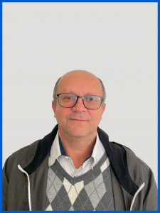
The event is proposed by Professor Dr. Everton da Silva, who is assigned to the Department of Geosciences at the Center for Philosophy and Human Sciences of the Federal University of Santa Catarina. He has been accredited to the Graduate Program in Transportation Engineering and Territorial Management (PPGTG) since its implementation in 2015, where he supervises master’s students in the concentration area of “Territorial Management” and the research lines of “Multipurpose Cadastral System” and “Territorial Planning.”
Since graduating with a degree in Surveying Engineering in 1992, he has been involved in activities related to Multipurpose Cadastre, with experience in various municipalities across the country, both as a private sector professional and as a public servant in the capacity of a professor, through extension and research initiatives.
At the Lincoln Institute of Land Policy in the United States, he began in 2010 as a collaborating professor in the Program on Latin America and the Caribbean for distance and in-person courses in different countries, as well as at events that discuss land policies in Latin America, contributing mainly to the cadastral theme.
At the Ministry of Cities, he was part of the GT-Cadastro, participating in workshops and seminars that supported the development of the National Guidelines for the Implementation of the Multipurpose Cadastral System in 2009, from which numerous seminars and training courses were developed, in addition to learning support materials. Also with the Ministry of Cities and the former Ministry of Regional Development, he coordinated the project titled “Multipurpose Cadastral System applied to Municipal Management,” whose main goals were the revision of the National Guidelines for the Implementation of the Multipurpose Cadastral System in Brazilian municipalities and the update of the distance learning cadastre course for the ministry’s Capacidades platform. This project also resulted in the publication of a book with the same name (see at https://doi.org/10.5281/zenodo.7869277) and the publication of Ordinance N. 3242/2022/MDR.
In 2013, he participated in the technical committee of the XVII Brazilian Congress of Valuation and Surveying Engineering, organized by the Brazilian Institute of Valuation and Surveying Engineering (IBAPE-SC). The event was attended by about 550 people and included discussion panels, paper presentations, and conferences.
In 2016, he contributed to the formation of the Red Académica de Catastro Multifinalitario – RACAM, which aims to disseminate cadastral culture and train people to improve activities related to cadastral administration and management, seeking the implementation of land policies that favor the reduction of social inequalities in the region.
Professor Everton da Silva is the leader of the Grupo de Observação e Transformação do Território (GOTT), coordinated the Congress of Multipurpose Cadastre and Territorial Management in 2018, 2020, and 2022, and served as a member of the organizing committee for this same event in the 2012, 2014, and 2016 editions, where he also participated as a member of the scientific committees. Since the 2010 edition, he has been contributing to the discussions at round tables, either as a speaker or moderator.
At the Department of Geosciences at UFSC, he participated in projects linked to the Ministry of Regional Development that aimed to create geotechnical aptitude maps to address natural disasters. Two seminars were held to disseminate the project results, and he was part of the organizing committee. In recent years, he has participated in several relevant national and international events in his field of expertise.
In collaboration with GIZ (Deutsche Gesellschaft für Internationale Zusammenarbeit) and the Ministry of Cities, he coordinated the project titled “Pilot Group for the Distance Learning Course: Multipurpose Cadastral System Applied to Municipal Management,” whose main goals were the activation of the CTM Community on the REDUS platform and the execution of the pilot group for the distance learning course in two phases: Phase I – Pilot group for the distance learning course with tutoring; and Phase II – Remote workshops and peer-learning meetings.
Another activity he has been developing since 2023 is the coordination, with the support of the Ministry of Cities and GIZ (ReDUS – Rede de Desenvolvimento Urbano Sustentável), of the Community of Practices in Multipurpose Cadastral System (Comunidade CTM), which meets monthly to discuss topics of interest to people who work directly or indirectly in the cadastral area. This activity led to the organization of a complementary event to the congress titled “1st In-person Meeting of the CTM Community.”
Currently, he coordinates, together with the Graduate Program in Transportation Engineering and Territorial Management (PPGTG), the Brazilian Federal Revenue Service Master’s Class, which seeks to train and contribute to supporting advances in the cadastral area of this institution, especially in the Sistema Nacional de Gestão de Informações Territoriais (SINTER).
Now, hear from the event coordinator, Prof. Dr. Everton da Silva, and don’t miss the chance to accept this special invitation!


